Abstract
Rapid, safe, and cost-effective assessment of windfall damage after storms is essential for effective forest management and mitigation of economic impacts. This study investigates the application of drones in assessing windfall damage efficiently. Utilizing high-resolution drone ortho-imagery, we aim to enhance current damage assessment methods. Our findings suggest that automated image analysis can detect, measure and geographically locate fallen trees in aerial photographs taken by drones efficiently. Thus, our approach can rapidly and safely quantify storm damage, providing valuable data for forest management and economic impact analysis.
Introduction
In the night of October 29 to 30, 2018, Storm Vaia caused widespread destruction across parts of Europe, including Graubünden in Switzerland. With wind speeds exceeding 180 km/h at Piz Martegnas, the storm inflicted severe damage, toppling high-voltage pylons and affecting 100 hectares of forest. The resulting damage exceeded 60,000 cubic meters of timber. While significant, such events are not unprecedented in the region’s history. Forests in mountainous regions like Graubünden serve crucial protective functions against natural hazards such as avalanches and rockfalls. Post-disaster, it is vital to quickly assess the extent of forest damage to address immediate protective needs and manage timber resources. Traditionally, district foresters conduct on-site inspections to make decisions regarding storm wood clearance and temporary protective measures.
Methodology
A collaborative project initiated by the WSL Institute for Snow and Avalanche Research SLF and developed by the Institute of Photonics and Robotics (IPR) at the University of Applied Sciences Graubünden aimed to refine damage assessment methods using aerial images. Commissioned by the Office for Forests and Natural Hazards (Amt für Wald und Naturgefahren, AWN), SLF executed several drone flights, one of them over Val Mela, an area impacted by Storm Vaia. The captured ortho aerial images provided a precise, distortion-free, vertical view with a resolution of approximately 2 cm per pixel. These high-resolution colour images facilitated the detailed analysis required for accurate damage assessment.
Results
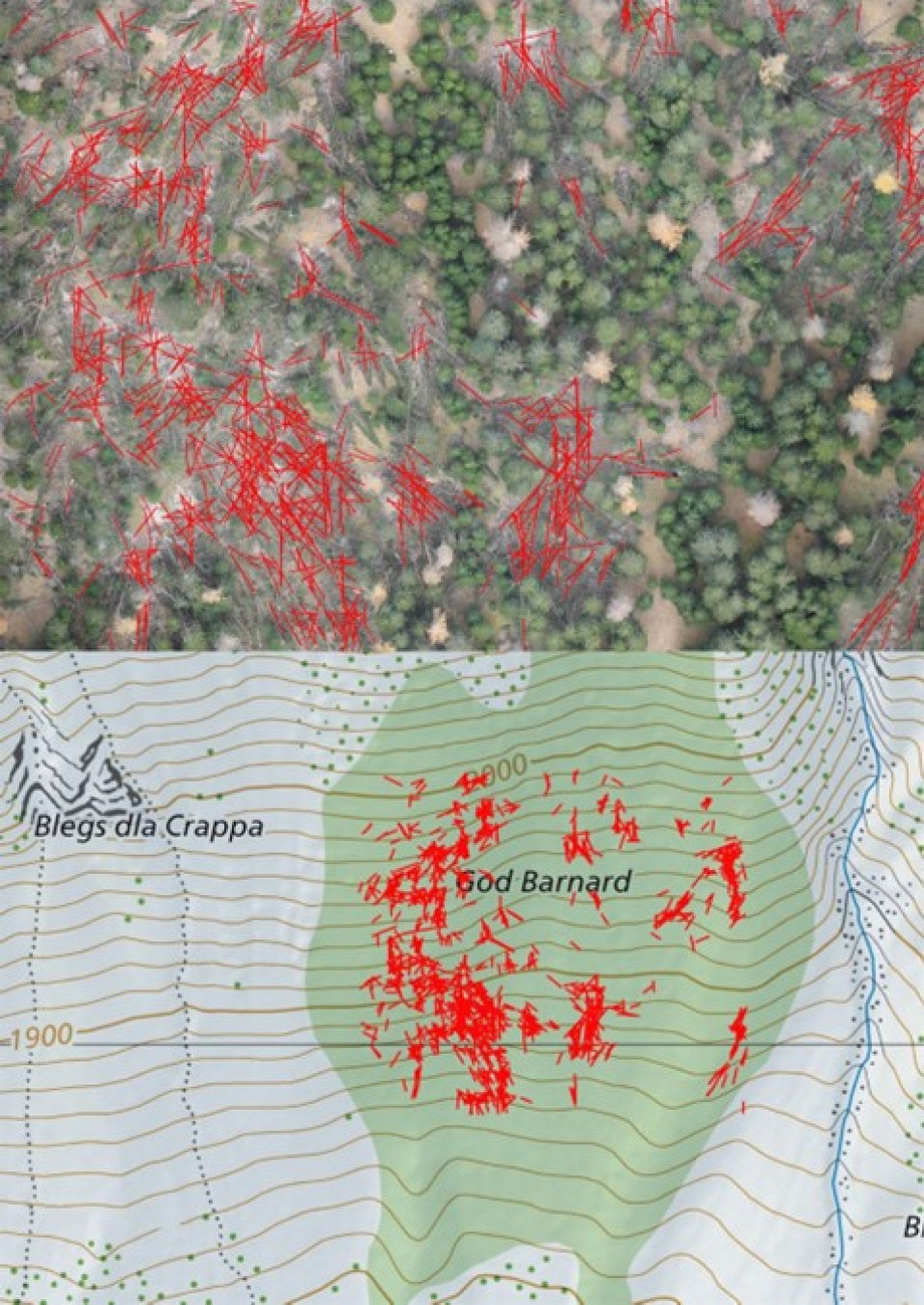
The University of Applied Sciences Graubünden developed software to automatically evaluate these images. The software detected, measured, and geographically localized fallen trees (Fig. 1), enabling the compilation of statistics on storm-damaged timber and its distribution. This approach allows for rapid, efficient damage analysis without the need for hazardous on-site inspections.
By recording the damage using drones, there is no need for dangerous access and manual recording by people walking in the damaged area between freshly fallen trees in a rough mountain area that is difficult to access with the potential risk of falling. The results are also available much faster. The rapid determination of the amount of storm-damaged timber also makes it possible to assess the economic impact of the supply of storm-damaged timber on the timber market – an important economic factor in Graubünden – and its influence on the price of timber at an early stage.
Discussion
The developed software represents an early-stage technology that requires further validation. Future work will involve comparing the automated estimates of storm-damaged timber with manual measurements and actual cleared quantities. To this end, the involved Grisons institutes plan to undertake a joint research project to further refine and validate this technology.
Conclusion
This study lays the groundwork for improving forest damage assessment post-storm events through the use of high-resolution aerial imagery and automated analysis. By enhancing the speed and safety of damage assessment, this method holds promise for future applications in forest management and economic planning

Figure 1. Storm affected mountainous region with windfall. Red indicates fallen trees detected by our software. Top: Areal photograph. Bottom: Ortho-map overlayed with fallen trees (image credit: Federal Office of Topography swisstopo).
Figure 1. Storm affected mountainous region with windfall. Red indicates fallen trees detected by our software. Top: Areal photograph. Bottom: Ortho-map overlayed with fallen trees (image credit: Federal Office of Topography swisstopo).

