Introduction
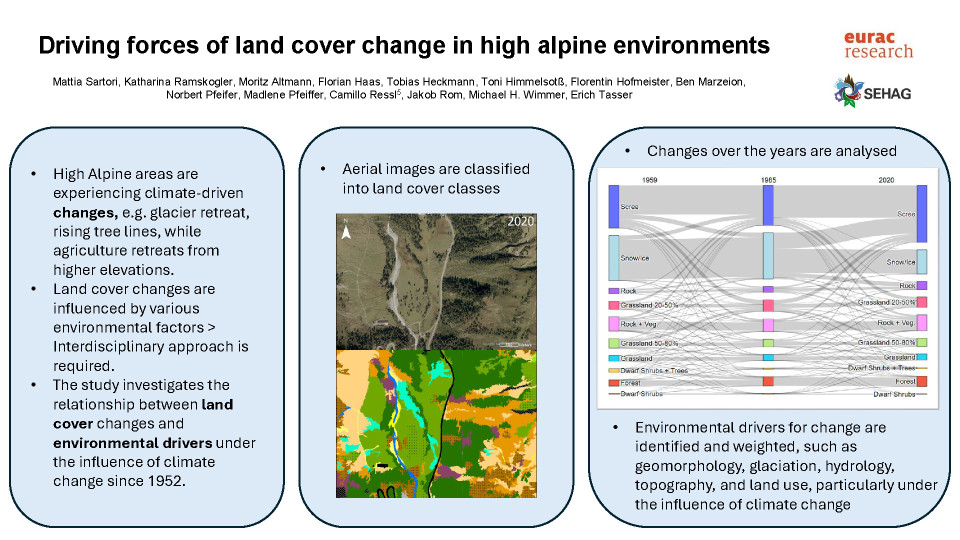
The impact of climate change around the world is much more evident in high alpine regions. The European Alpine region is a good example for this phenomenon. In fact, this region is undergoing a rapid transformation in climate dynamics, which are influencing the evolution of land cover types. The glaciers retreat and the forest and tree line, as well as the alpine vegetation types, rise. At the same time, however, agriculture is increasingly retreating from the higher elevations, which is also leading to shifts in vegetation. These processes are initiated and accelerated by a multitude of influencing factors, necessitating an interdisciplinary approach to comprehend their causes and potential future developments. This research is integrated within the broader context of the SEHAG project, an interdisciplinary approach for investigating the sensitivity of Alpine geosystems to climate change since 1850.
Aim
The Martell Valley (South Tyrol, Italy) and Kauner Valley (Tyrol, Austria), emblematic of the fragile alpine regions, have undergone significant transformations over the past seventy years. The aim of our study was to investigate the intricate relationship between land cover changes and various environmental drivers, such as geomorphology, glaciation, hydrology, topography, and land use, particularly under the influence of climate change, since 1952. Thus, we wanted to address the following research questions: (i) What were the specific drivers leading to land cover change and how did they interact with each other? (ii) Were there area-specific drivers that caused certain patterns in one study area or the other?
Methods
To conduct this study, we used aerial images to create high-resolution land cover maps for the two study areas for 1952, 1985, and 2020. We performed yearly automated image segmentation based on spectral differences, followed by manual classification into nineteen predefined land-cover classes. Historical ground-level photographs helped identify ambiguous land surface types. We also collected data on key drivers of climate, geomorphology, land use, glacier condition, and topography. Multivariate analysis and geographically weighted regression accounted for spatial variations in environmental impact and identified correlations between land cover change and drivers.
Results and outlook
Results from the land cover classification show that significant changes have taken place in the last 70 years. We observed that the class “ice/snow” decreased by 46% in the Martell Valley, and by 28% in the Kauner Valley. The total area covered by vegetation increased by 10% in the Kauner Valley and by 4,5% in the Martell Valley since 1950. The land cover class “alpine grassland” showed a particularly strong growth gaining 2.8 km2 during the investigation period, which is 5% of the total surface. Differences between the two investigation areas could also be observed. The land cover class “alpine grassland” that showed a gain in coverage of 60% in the Kauner Valley, lost 20% of coverage in the Martell Valley. We identified the Drivers affecting land cover change dynamics to be mostly related to microclimate and topological factors. Furthermore, differences between the two study areas can be led back to differences in the geological composition of the sites.
Overall, this study not only helps us to advance our scientific understanding of the response of high alpine ecosystems to climate change, but also emphasises the importance of interdisciplinary approaches in understanding and subsequently managing environmental problems. It also shows the opportunities for research offered by historical ground level photographs taken. We are therefore currently working on a citizen science initiative in which we offer all the opportunity to re-photograph historical photographs on site via an app. We will then analyse the collected images scientifically.
Quiz question
Land cover class changes in high alpine environments...
are driven by variations in climate and the impact of human behaviours.
are driven by multiple interacting environmental factors strongly influenced by climate change.
are mainly defined by glacier retreat, forest expansion and wasteland/scree increase.

